


An electronic newsletter for the science education community
Interactive Atlas Maps Debut Online
If you’re a fan of Project 2061’s conceptual strand maps in Atlas of Science Literacy, a new Web-based tool is ready to give you a glimpse into the next generation of strand maps. Five digital maps allow you to move easily within an Atlas map and to jump quickly between maps on different topics. If you’re new to Project 2061’s maps, the interactive maps are a great way to learn about the detailed connections within and across topics that are the hallmark of Atlas of Science Literacy (American Association for the Advancement of Science [AAAS], 2001 and 2007). In time, the digital maps will provide convenient access to a range of resources aligned to key science ideas.
With support from AAAS’s William T. Golden Endowment Fund for Program Innovation, Project 2061 has developed a prototype set of five interactive and interrelated maps based on maps originally published in Atlas of Science Literacy (visit the prototype at http://flora.p2061.org/SVGMaps). The current set of maps includes learning goals from Chemistry, Ecology, Earth Science, Human Biology, and Physics. Each map focuses on an important K–12 science topic and shows how benchmark ideas (in boxes on the maps) that are relevant to a topic relate to and build on each other from grade to grade. Map users can study the relationships between the ideas and, eventually, access instructional and assessment resources related to those ideas. The ideas on the maps are drawn from widely accepted student learning goals as spelled out in Project 2061's Benchmarks for Science Literacy (AAAS, 1993) and the National Research Council’s National Science Education Standards (1996).
Navigation Made Easy
By displaying graphically the connections between learning goals, Atlas maps
have always offered a fresh perspective on how student understanding might grow from
K to 12. Now, the interactive maps make it even easier for educators to explore those
connections within and across maps.
“To make navigating the maps as useful and flexible as possible, we have borrowed concepts and interface elements from Web mapping applications. Anyone who has used Google Maps, Google Earth, or MapQuest will already know how to interact with the maps,” said Francis Molina, Project 2061’s technology director. “The most straightforward way of moving around is by dragging the map. The user can also click the directional arrows in the Zoom and Navigation panel or drag the area highlighter in the map thumbnail, which always shows you where you are on the map.”
The map thumbnail in the lower right corner is especially helpful for reminding users of the full set of ideas and skills that students are expected to learn about a topic even as they focus in on a single grade level or particular learning goals.
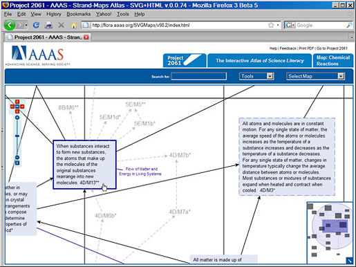
In addition to connections between the benchmark ideas that are displayed on a map, each map also shows links to closely related ideas that appear on other maps. Unlike maps in the printed Atlas, which use a code to identify these related ideas, the interactive digital maps display the full text of the related benchmark ideas when users click on the code. In addition, users get a list of the other maps on which the ideas appear.
Another type of connection is a cross-reference, which indicates that the benchmark appears on the maps that are listed. A cross-reference link allows users to jump quickly from the current map to a related map that shares the same benchmark. On the related map, any benchmarks that are common to both maps are highlighted in yellow.
Toward a Complete Interactive Atlas
When complete, the interactive strand maps will serve as a “one-stop
resource” for studying learning goals and for accessing instructional resources
and assessment items aligned to those goals. For selected benchmark ideas on each map,
users will be able to click on an idea to access a tabbed set of resources aligned to
that idea. These resources include (1) a clarification of what the benchmark
idea expects students to know; (2) a map of connections between the
idea and benchmark ideas that precede and follow it; (3) student misconceptions related
to the idea that can help teachers and curriculum developers better understand their
audience; (4) phenomena that provide evidence of the idea and activities related
to those phenomena; and (5) representations that help to clarify the
idea for students.
The existing prototype already includes a search feature that covers all of the K–12 benchmarks mapped in Atlas 1 and Atlas 2. Typing search terms into the search field and pressing Enter on the keyboard returns a clickable list of maps that contain the search terms. While all relevant Atlas maps appear in the list, only the five initial maps can currently be clicked on and viewed.
Project 2061’s next step is to secure funding to develop interactive versions of all of the nearly 100 maps found in volumes 1 and 2 of Atlas of Science Literacy. We also plan to provide a good variety and number of aligned resources for each of the maps.
Explore the Interactive Atlas of Science Literacy demonstrator. The maps are best viewed on a Windows or Macintosh computer using Firefox 3 (http://www.mozilla.com/en-US/firefox/) or Opera 9.51 (http://www.opera.com/). Alternatively, Windows users can view the maps with Internet Explorer 6/7 with the Adobe SVG Viewer plug-in (download the plug-in at at http://www.adobe.com/svg/viewer/install/).
# # #
For more information about Project 2061's interactive strand maps, please contact:
Technology Director: Dr. Francis Molina, (202) 326-7002
References
American Association for the Advancement of Science. (1993). Benchmarks for science literacy. New York: Oxford University Press.
American Association for the Advancement of Science. (2001). Atlas of science literacy. Volume 1. Washington, DC: Author.
American Association for the Advancement of Science. (2007). Atlas of science literacy. Volume 2. Washington, DC: Author.
National Research Council. (1996). National science education standards. Washington, DC: National Academy Press.
Also in the May/June 2008 issue: